Showing posts with label Mississippi River. Show all posts

2014-06-22

1872 Routes from Caledonia MN to Tipton KS

Figure 1. Rivers and cities from Caledonia to Tipton
Original publication on 2013.10.30. Updated  2013.11.10 and 2014.06.21. © Thomas G. Kohn, 2014.

Katherine Reinert and her family of five children arrived in Tipton, Kansas after a trip of 600 miles or more from Caledonia, Minnesota. Although a family document asserts the travel was by wagon train, no established trails cut a diagonal path from southeastern Minnesota to central Kansas. Even today, the route would pass by larger cities like Dubuque, Omaha, and Topeka to reach the destination. Travelling first down the Mississippi River to some terminus downstream seems more logical (Figure 1). Clinton, Davenport, or Burlington in Iowa or Hannibal in Missouri are possible locations for the transition from travel by river to travel overland. The river port of St. Louis is a possible location for transfer to a steam ship up the Missouri River.

Overland from Iowa

Travel from Clinton, Davenport, or Burlington Iowa seems unlikely at first glance. However, I recently learned of the Lane Trail, which was a popular route for free-state partisans who hoped to affect the so-called Kansas Question as the state formed. The trail was in use from 1856 through at least 1861. Further research may clarify its importance in the 1870s.

Overland from Hannibal

At Hannibal, a traveler would find easy connection from riverboat to rail. The eastern terminus of the Hannibal to St. Joseph Railway is within a tenth mile from the city's river landing. Soon after the last section of railway was completed in 1859, President Abraham Lincoln rode the system to make a speak in Council Bluffs, Iowa. The railway became an important 1860 link from post offices in the east to the Pony Express and then later to the Overland Stage routes. A short-lived 1862 contract with William A. Davis allowed for sorting mail in special train cars and performing functions previously done in St. Joseph. The connection between Hannibal and St. Joseph remained in place through more than a century and under several companies.

In 2014, I drove alongside the train route to understand the terrain and distance. The land has gently rolling hills and large expanses of farmland today. The passage in 1872 was likely through lightly forested land. The route arcs northwest from Hannibal to Palmyra, Missouri. Then the route angles southwest to Monroe before it continues almost due west toward St. Joseph. The train likely stopped in the major towns of Macon, Brookfield, Gallatin, Chillicothe, and Breckinridge.

From the 1860s through the 1880s, St. Joseph was a major center of provisioning wagon and stage travel west into Kansas. Warehouse Row consisted of a 4- by 6-block area that provided livery, livestock, housewares, foods, clothing, and many other supplies that would be scarce in the pioneer areas of Kansas and Nebraska. No bridges spanned the Missouri River until the St. Joseph Swing Bridge was built in 1873 for rail traffic. Prior to that, crossing the river was only by one of several ferries. Urban development has obliterated most landmarks of late 19th-Century St. Joseph, and several websites provide photographs from that time.

Up the Missouri River

The Missouri River is navigable from its confluence with the Mississippi north of St. Louis, and steamboats made the journey on a regular schedule. Four river towns were growing in importance along the Missouri River border with Kansas: Kansas City, Leavenworth, Atchison, and St. Joseph. The distance up the Missouri from its confluence is 515 miles to Kansas City and about 600 miles to St. Joseph.

From Kansas City, steamboats operated on the Kansas River as far upstream as Fort Riley, with the height of activity stretching from 1854 to 1866. However, this extension of river travel is less likely, since from the middle of the 1860s, rail service took over the freight transport.

The Prairie Trails

Figure 2. Trails of the American prairie, 1860s
Our understanding of overland travel in pioneer times is colored by mythology built by the Western genre of movies and television series. Among other common assumptions is the impression that the transfer from steamboat to wagon train means a change from relative ease to arduous work. That work starts with buying wagons and teams of horses or oxen. At the same time, others in the forming wagon train must purchase supplies for the trail journey and essentials for setting up the new home. Others likely must seek out information on what to expect on the trail and what trail markers might indicate a necessary change in the path.

Through the early 1870s, the lower section of the Kansas River as it approached Kansas City provided the eastern termini of the Oregon Trail, the California Trail, and the Santa Fe Trail (Figure 2). Our current understanding of “the Trail” is misleading. No pioneer trail had longlasting markers, and the verbal directions were shrouded by the vastness of the American frontier prairie. Frederick A. Wislizenus wrote in his 1846 diary of travelling the Santa Fe Trail, “This morning we passed the road to Oregon, that leaves, about eight miles from Round Grove, the Santa Fe Road, and turns to the right towards the Kansas [river]. A way post had been put there, marked: ‘Road to Oregon.”” He was lucky to have seen the way post, since the usual directions referred to a grove of trees or a bend in the river.

The Trails into Kansas

Rivers, towns, and forts in Kansas
Perhaps the Caledonia-Tipton wagon train followed the Oregon Trail as far as Topeka and then headed west for Fort Riley (Figure 3). The trails following the Smoky Hill River and Solomon River were well established by 1872. The likely route continued from Fort Riley along the Smoky Hill Trail and, at the confluence of the Solomon River west of Abilene, the group might have chosen to follow the Solomon River northwest, while the Smoky Hill Trail headed west toward Salina and Fort Hays.

Speed of Travel

Travel by stage coach could be as fast as seven miles per hour over short distances, but loaded wagons might travel only a couple miles per hour—or even less with wet weather or wagon breakdown. The stage coach travelled through the night and stopped only to allow momentary rest and a meal. While stage coaches sped from one station to another and received a fresh team of horses and drivers, the oxen or horses pulling the load of the wagon train needed rest overnight. Making camp, tending the livestock, and bedding down for the night made for a shorter daytime of travel. The likely time on the trail would have been a week for the trip from Fort Riley, and possibly as much a month for the trip from St. Joseph.

Railway Alternatives

Several biographical sketches in Early Day Couples of Tipton, Kansas and The People Came refer to settlers arriving by train at either Wilson or Cawker City. Then the settler had an easier 38-mile route, directly north from Wilson to Tipton or a very short 14-mile route directly south from Cawker City. Often, however, the date of arrival is not given. Therein lies the tough history.

The desirability of rail passage from the Mississippi River to the western territories and state was long felt. As early as 1834, Dr. Samel K. Barlow was an advocate of railroad building. Nonetheless, surveys even of Missouri were not active until a period from 1853 to 1861. The first active rails reached but 125 miles west of St. Louis, to Jefferson City, Missouri.

Many speculative railway companies actively lobbied the first territorial legislature and occasionally received charters for developing rail travel, as early as 1855. The early focus, though, was routing from Kansas City, Leavenworth, and Atchison southwest to Lawrence and Topeka or yet further south toward the Gulf of Mexico or Santa Fe, New Mexico. Cutler reported that, finally, “on March 20, 1860, the first iron rail on Kansas soil was laid at Elwood, Doniphan county, opposite St. Joseph.” But the line was only five miles long, the track rough, the way crooked.

The impatient Kansas legislature convened and enacted a five-point plan for rail development. In fits of work, the rail system expanded to Lawrence, Kansas in 1864 (40 miles), to Topeka in 1865 (another 27 miles), and nearly 100 miles further west in 1866. Finally in 1869, the governor could announce that rail had been laid to within 35 miles of the state’s western boundary. The whole 400- by 200-mile area of Kansas was served by 1,283 miles of track in 1870. However, the lines were operated by a large number of independent companies, making connections difficult, if they existed at all. Blackmar reports that The Kansas Monthly of November 1879 listed a Union Pacific branch that served Osborne City, Kansas and a Kansas Pacific branch that served Beloit, Kansas. Likely it was only then that settlers could begin using rail transport to Osborne county and Mitchell county.

For that matter, the trail system was being bypassed by the establishment of what were then called “highways,” collection of road taxes, and setting regulations for the engineering and building of the roads. The stage routes that had connected the system of forts in early pioneer days, were being rebuilt as territorial roads. The legislatures of 1855, 1857, 1859, and 1861 created a total of 156 highways. The 1863 legislature provided for bridges, culverts, and other improvements, without which the roads were impassable at some seasons each year. The 1871 legislature provided that all section lines in 14 counties—Mitchell county among them—be public highways.

Relevant Links

2013-11-13

Houston County, Minnesota—local development


First publication 2013.11.15. © Thomas G. Kohn, 2013.

As part of southeastern Minnesota, the county is in the “Driftless Zone,” which is marked by the absence of glacial drift[8] and presence of bedrock cut by streams into steep hills. The plateau that surrounds Caledonia includes flat, fertile farm land and hilly, verdant pasture land.

Figure 10. Mississippi transportation, undated.
Navigation up and down the Mississippi encouraged growth of the county (Figure 10). Records of river transport document shipping from as early as 1844. The shipping season typically opened in April, after the river is free from ice. In 1855, a ferry from La Crescent to La Crosse was licensed. Named the “Wild Kate,” it operated without a regular timetable from its normal berth at La Crosse (Figure 11). Two horses powered a treadmill for the crossing. An unreliable steam ferry named “Honey Eye” soon replaced Wild Kate. However, its steam engines had little capacity, and often the ferry “had to tie up to an island, let the steam go down, take off the safety valve, and with buckets fill the boiler, then get up steam again and finish the trip.”[9] After two years of such service, the ferry was abandoned and another company provided better service through 1878.

Figure 11. Mississippi ferry at Redwing, about 1900.
Railroad companies were provided bonds for building by the Minnesota Supreme Court in 1857, in the face of popular and legislative opposition. However, referenda and laws were passed that obstructed state bonds for railway development through 1860. Although the battle over state funding of railway building raged until 1881, the private companies began to install their lines. “A part of the great St. Louis and Minneapolis line runs through the county north and south near the Mississippi River. Another road runs in the valley of the Root River east and west, connecting with the Mississippi road at the river. The third railroad in the county is the ‘Caledonia and Mississippi,’ which, from the junction on the river, follows up the Crooked Creek in a northerly direction to Caledonia, the shire town, where it deflects toward the south, and passes through Spring Grove, and thence on to Preston, its present terminus. This line was undertaken by local enterprise and is of the standard narrow gauge.”[10]

Figure 12. Harvesting flax.
It is possible that John Reinert brought tools of his trade with him to pioneer America, where there would be a ready market for both linen thread and cloth. This hypothesis may be hard to prove, since tax records have not been found to date. Writing in 1882, Neill reported that flax cultivation had begun with one acre in 1878, which produced four bushels of seed.[11] Even through the 20th Century, Minnesota was one of several states that devoted many acres to flax.[12] Flax had become competitive in northern states like Minnesota because these states need fast maturing, cool season crops. Flax can be planted in April, as soon as the soils begin to warm, and it can be harvested in August (Figure 12), well before early frosts.[13] However, since about 1970, American flax production has failed to compete with imported textiles, whether as raw materials or as finished goods. The plat maps of 1931[14] report that neighboring farms to the Reinert home had cattle, hogs, chickens, and geese. An average 120 acres of each farm supported the livestock with grain and pasture.

The county population grew quickly in the 1860s, decreased slightly from 1900 to the 1930s, and gradually grew to the 2010 population of 19,000.[15] The town of Caledonia has grown steadily, although slowly. La Crescent growth began only in the middle of the 20th Century, and its growth has been the driver of county growth since then. Of the other villages and townships, only Spring Grove village, Houston village, and La Crescent township have 1000 residents or more. The remaining 19 villages and townships have not grown much beyond populations of 500 each.

Figure 13. Root river in Houston county.
The Root River and its broad floodplain (Figure 13) divide the county into a north third and a south two-thirds. In the north are the villages of Money Creek (unincorporated), Pine Creek (unincorporated), Houston (population 979 in 2010), Hokah (population 580), and the largest town of the county, La Crescent (population 4,830). La Crescent overlooks the Mississippi floodplain and slow-moving river, almost directly west from La Crosse, Wisconsin. South along the Mississippi are the towns of Brownsville (population 466) and Reno (unincorporated).

The southwestern two-thirds of the county populate the rolling plateau above the Mississippi. Caledonia (population 2,868) sits in the center. The other towns on the plateau are Yucatan (unincorporated, township population 351), Sheldon (unincorporated, township population 289), Black Hammer (unincorporated, township population 326), Riceford (unincorporated), Newhouse (unincorporated), Spring Grove (population 1,330 and Spring Grove township population 422), Wilmington (unincorporated, township population 472), Eitzen (population 243 and Winnebago township population 257), and Freeburg (unincorporated, Crooked Creek township population 323).

Figure 14. Map of Caledonia, 2001.
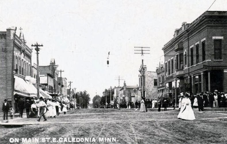
The town of Caledonia is a typical American small town (Figure 14). The streets are broad and mostly planned in a matrix of parallels and right angles. The businesses form a tightly-knit downtown that has stood for one hundred years or more (Figure 15). The largest buildings in Caledonia are the county courthouse, which was built in the 1890s, and St. Mary Catholic church, which was originally built in the 1880s. Both are located in the southern central area of town, within a few blocks of each other. The brick or stone buildings that date from before 1885[16] have weathered well, although some façades have received incongruent modernizations. A line of newer businesses skirts the western edge of town along Highway 44-76.


Figure 15. Caledonia downtown, 1907.
The homes developed clearly in separate additions: a few frame homes from the end of the 19th Century still stand, a group of homes built in the 1920s occupies one section of town, more modest homes built after the Great Depression are in another pocket, and in several groupings are the homes built to house the smaller families that formed after soldiers returned from World War II. Here and there, you can find homes built in the 1960s through the 1990s that fill in vacant lots left during the other periods of development. Along State Route 44-76 are the most recent businesses that include gas stations, motels, fast food, and restaurant-bars. The nearest city for movies and other entertainment is seventeen miles away: La Crosse, Wisconsin.[17]

Previous sections: Background for family history, Parish
Next sections: History, Reinert History in the Area, Travel to Kansas in 1872, Tipton KS, Seguin KS, La Crosse WI

Notes

8

See Coulee Region, accessed 2013.10.22.

9

Neill, p. 285.

10

Neill, p. 258 (writing in 1882 about the Chicago, Milwaukee and St. Paul company).

11

Neill, p. 292.

12

378,000 acres in 1920 Minnesota, 1.6 million acres in 1943, and diminishing lately to only 10,000 acres, as cited in a Minnesota farms publication.

13

Thomas Jefferson Agricultural Institute, in their online essay on flax.

14

Unattributed, Atlas and Farmers’ Directory of Houston County,. Webb Publishing Company (St. Paul MN), 1931. Personal copy available as scanned images.

15

Population figures cited in Wikipedia's article on Houston county and linked entries for each township and town.

16

Neill, p. 271.

17

Nine years after Susanna Reinert had left the Caledonia area for Tipton, Kansas with her mother, sisters, and brothers, she moved to La Crosse with her husband John M. Kohn and three children. They had moved there at the encouragement of her brother-in-law Mathias Kohn, who had owned and operated a well-respected and successful saloon and boarding house in La Crosse since 1864.

Houston County, Minnesota—background for family history

First publication 2013.11.13. © Thomas G. Kohn, 2013.

John Reinert and his wife Katherine Blasius-Reinert arrived in the U.S. around March of 1867. To date, no ship’s passenger list has been found to document their exact arrival.[1] The Prussian commander of the militia signed a permit for emigration on 9 February 1867. If the family left Germany soon afterward, travel to Le Havre, France might require a week, and ship passage about three weeks. Thus, it is likely they arrived in March.

The family traveled with five children aged 19 (Susanna), 16 (Nicholas), 14 (Peter), 7 (Maria), and 3 (Gertrude). Their most likely port of arrival was New York City, and they may have been processed through Castle Clinton (also called Castle Garden).[2] However, it is possible their ship landed in Hoboken NJ. The family stayed some time with one or more of Katherine’s siblings. Her brother Nicholas Blasius lived in New Trier township, Cook county, Illinois; her sister Anna Catharina Blasius-Schmitz-Simon also in New Trier township or the nearby town of Wilmette; and her brother Johann Blasius lived in Chicago.

Figure 1. Caledonia township, Houston county MN, 1871
An informal family history holds that they had settled near Caldedonia in or after 1867. By the Ninth U.S. Federal Census of 1 June 1870, John Reinert and his family lived in Houston county, Minnesota. Their home in Minnesota was a farm about one and one-half miles north and three to four miles west (red square in Figure 1) of the village of Caledonia (red polygon). The farm might have included crops like flax, which the father John Reinert had experience with in Germany. No deed exists to show ownership, so it is likely they leased the farm.

Figure 2. John Reinert Household entry, U.S. Federal Census 1870
The enumeration of household 127 in the 1870 census (Figure 2)[3] identifies John Reinert as “John Rinerd” (age 50, farmer with real estate valued at $1700 and personal estate valued at $400) and his family as Catherine (46, keeping house), Susanna (22), Nicholas (19), Peter (17), Mary (10), and Gertrude (5).

Other families enumerated before and after the Reinerts include these households.
  • William Paddock (dwelling 118, household 112, in section 10)
  • James Mulligan (dwelling 119, household 113, in section 10)
  • Delmer Irvin (dwelling 120, household 114, section 10)
  • Michael Lorig (dwelling 121, household 115, not found as an identified land owner)
  • James Lochead (dwelling 122, household 116, “Lockard” in section 3)
  • John Schmitt (dwelling 123, household 117, in section 3)
  • Gunder Knudson (dwelling 124, household 118, in section 3)
  • Edmund Powell (dwelling 125, household 119, in section 3)
  • Jacob P. Bakin (dwelling 126, household 120, “Becker” in section 3)
  • Dwelling 127, household 121 is the John Reinert family
  • Daniel McCarty (dwelling 128, household 122, in section 3)
  • Michael Allen (dwelling 129, household 123, “M. Ellings” in section 9)
  • Patrick Jennings (dwelling 130, household 124, in section 9)
  • Catherine McGloughlin (dwelling 131, household 125, “Laughlin” in section 9)
  • Michael Jennings (dwelling 132, household 126, perhaps occupant of “P.Jennings” in section 4)
  • John Hashite (dwelling 134, household 128, “M.Hastings” in section 4?)
  • Nicholas Pirrotte (dwelling 135, household 129, in sections 9 and 10)
  • Frank Wis (dwelling 136, household 130, not found as an identified land owner)
  • Anna Shields (dwelling 137, household 131, not found as an identified land owner)
Figure 3. Neighboring households to John Reinert, Caledonia twp
The household locations are shown as numbers in Figure 3. Two small squares indicate dwellings that are not enumerated with a family. They are possible locations for the John Reinert family.

It is likely that John swore his intention to become a citizen at the District Court of Minnesota in Caledonia on 23 October 1867. However, the signature could be read as “John Reinart,” who was a different immigrant who lived in Houston county at the same time.

John Reinert died from throat or neck cancer in March of 1871. The parish registers do not include burials of 1871,[4] and his grave is not recorded in the Caledonia parish cemetery. Katherine and the children kept the farm running for about a year.

Geography

The land features of Houston county, and for that matter, much of Minnesota and Wisconsin along the upper Mississippi River, resemble those of the middle Mosel River. Meandering tributaries feed the broadly flowing Mississippi, which is bounded by the bluffs that rise above the river.

Figure 4. Map of Houston county, Minnesota, 2003
The Root River flows east through the north third of Houston county and beside the towns of Houston and Hokah. Tributaries of the Root River from the north are Storer, Silver, and Money Creeks. North of Houston on Money Creek, a tributary of the Root River, is the unincorporated village of Money Creek. Also north of the Root River are Pine Creek (unincorporated) and the largest town of the county, La Crescent, which overlooks the Mississippi floodplain across from La Crosse, Wisconsin. South along the Mississippi are the towns of Brownsville and Reno (unincorporated).

The southern three-fourths of the county rise as much as 500 feet above the Mississippi, and most of the climb occurs in the bluffs above the western bank of the river. Tributaries of the Root River from the south are, in westward order, Thompson Creek (formerly also known as Indian Spring Creek), Crystal Creek, and Badger, Beaver, and Riceford Creeks. Thompson Creek was named in honor of Edward Thompson and his brother, Clark W. Thompson, the principal founders of Hokah. Caledonia sits in the center of the broad plateau above the rivers, among gently rolling hills that might have reminded John Reinert and his family of the plateaus above Wasserbillig and Igel. The land is fertile but often steeply sloped. The farming typical to the area includes raising soy beans, corn, and livestock feed crops. The area is not populated very heavily today, with the average town size of about 700 residents. The other towns on the plateau are a combination of unincorporated areas (Yucatan, Sheldon, Black Hammer, Riceford, Newhouse, Wilmington, and Freeburg) and incorporated villages (Spring Grove and Eitzen).

Next sections: Parish, Local Development, History, Reinert History in the Area, Travel in 1872, Tipton KS, Seguin KS, La Crosse WI

Notes

1

Several online sources provide transcripts of ship manifests, including an index of arrivals by year,  (an index of departures by port, including Le Havre, a searchable database of NARA records, and the Dayton and Montgomery County Library has most volumes from Germans to America: Lists of Passengers Arriving at US Ports 1850-1897 (Ira A. Glazier and P. William Filby (the correct volume to search is Vol. 19).

2

On August 3, 1855, Castle Garden opened as an immigrant landing depot. The creation of Castle Garden represented a country at a crossroads, signaling a change in American immigration policy, and in the ways through which immigrants became Americans. Two out of every three immigrants to the United States in this period passed through the Castle Garden. It was closed on April 18, 1890 and immigrant processing was moved to Ellis Island.

3

Ninth U.S. Federal Census of Houston county, Minnesota; page 18, dwelling 127, household 121, lines 10 through 16.

4

Email of Oct 17, 2013 “Re: Parish records from 1871” from Maria Keefe (stmaryschurch@acegroup.cc) “Unfortunately, we have very few records dating as far back as 1871. Of the few we have, I was not able to locate any burial records for John Reinert.”