First publication 2013.11.15. © Thomas G. Kohn, 2013.
As part of southeastern Minnesota, the county is in the “Driftless Zone,” which is marked by the absence of glacial drift
[8] and presence of bedrock cut by streams into steep hills. The plateau that surrounds Caledonia includes flat, fertile farm land and hilly, verdant pasture land.
 |
| Figure 10. Mississippi transportation, undated. |
Navigation up and down the Mississippi encouraged growth of the county (Figure 10). Records of river transport document shipping from as early as 1844. The shipping season typically opened in April, after the river is free from ice. In 1855, a ferry from La Crescent to La Crosse was licensed. Named the “Wild Kate,” it operated without a regular timetable from its normal berth at La Crosse (Figure 11). Two horses powered a treadmill for the crossing. An unreliable steam ferry named “Honey Eye” soon replaced Wild Kate. However, its steam engines had little capacity, and often the ferry “had to tie up to an island, let the steam go down, take off the safety valve, and with buckets fill the boiler, then get up steam again and finish the trip.”
[9] After two years of such service, the ferry was abandoned and another company provided better service through 1878.
 |
| Figure 11. Mississippi ferry at Redwing, about 1900. |
Railroad companies were provided bonds for building by the Minnesota Supreme Court in 1857, in the face of popular and legislative opposition. However, referenda and laws were passed that obstructed state bonds for railway development through 1860. Although the battle over state funding of railway building raged until 1881, the private companies began to install their lines. “A part of the great St. Louis and Minneapolis line runs through the county north and south near the Mississippi River. Another road runs in the valley of the Root River east and west, connecting with the Mississippi road at the river. The third railroad in the county is the ‘Caledonia and Mississippi,’ which, from the junction on the river, follows up the Crooked Creek in a northerly direction to Caledonia, the shire town, where it deflects toward the south, and passes through Spring Grove, and thence on to Preston, its present terminus. This line was undertaken by local enterprise and is of the standard narrow gauge.”
[10]
 |
| Figure 12. Harvesting flax. |
It is possible that John Reinert brought tools of his trade with him to pioneer America, where there would be a ready market for both linen thread and cloth. This hypothesis may be hard to prove, since tax records have not been found to date. Writing in 1882, Neill reported that flax cultivation had begun with one acre in 1878, which produced four bushels of seed.
[11] Even through the 20th Century, Minnesota was one of several states that devoted many acres to flax.
[12] Flax had become competitive in northern states like Minnesota because these states need fast maturing, cool season crops. Flax can be planted in April, as soon as the soils begin to warm, and it can be harvested in August (Figure 12), well before early frosts.
[13] However, since about 1970, American flax production has failed to compete with imported textiles, whether as raw materials or as finished goods. The plat maps of 1931
[14] report that neighboring farms to the Reinert home had cattle, hogs, chickens, and geese. An average 120 acres of each farm supported the livestock with grain and pasture.
The county population grew quickly in the 1860s, decreased slightly from 1900 to the 1930s, and gradually grew to the 2010 population of 19,000.
[15] The town of Caledonia has grown steadily, although slowly. La Crescent growth began only in the middle of the 20th Century, and its growth has been the driver of county growth since then. Of the other villages and townships, only Spring Grove village, Houston village, and La Crescent township have 1000 residents or more. The remaining 19 villages and townships have not grown much beyond populations of 500 each.
 |
| Figure 13. Root river in Houston county. |
The Root River and its broad floodplain (Figure 13) divide the county into a north third and a south two-thirds. In the north are the villages of Money Creek (unincorporated), Pine Creek (unincorporated), Houston (population 979 in 2010), Hokah (population 580), and the largest town of the county, La Crescent (population 4,830). La Crescent overlooks the Mississippi floodplain and slow-moving river, almost directly west from La Crosse, Wisconsin. South along the Mississippi are the towns of Brownsville (population 466) and Reno (unincorporated).
The southwestern two-thirds of the county populate the rolling plateau above the Mississippi. Caledonia (population 2,868) sits in the center. The other towns on the plateau are Yucatan (unincorporated, township population 351), Sheldon (unincorporated, township population 289), Black Hammer (unincorporated, township population 326), Riceford (unincorporated), Newhouse (unincorporated), Spring Grove (population 1,330 and Spring Grove township population 422), Wilmington (unincorporated, township population 472), Eitzen (population 243 and Winnebago township population 257), and Freeburg (unincorporated, Crooked Creek township population 323).
 |
| Figure 14. Map of Caledonia, 2001. |
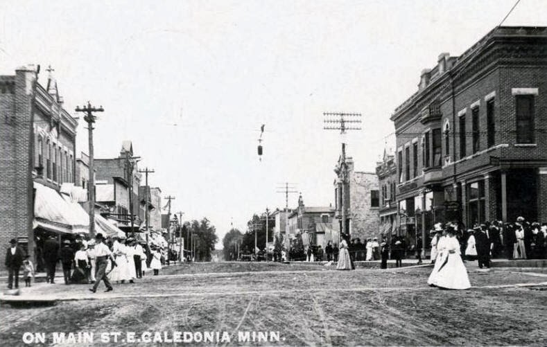
The town of Caledonia is a typical American small town (Figure 14). The streets are broad and mostly planned in a matrix of parallels and right angles. The businesses form a tightly-knit downtown that has stood for one hundred years or more (Figure 15). The largest buildings in Caledonia are the county courthouse, which was built in the 1890s, and St. Mary Catholic church, which was originally built in the 1880s. Both are located in the southern central area of town, within a few blocks of each other. The brick or stone buildings that date from before 1885
[16] have weathered well, although some façades have received incongruent modernizations. A line of newer businesses skirts the western edge of town along Highway 44-76.
 |
| Figure 15. Caledonia downtown, 1907. |
The homes developed clearly in separate additions: a few frame homes from the end of the 19th Century still stand, a group of homes built in the 1920s occupies one section of town, more modest homes built after the Great Depression are in another pocket, and in several groupings are the homes built to house the smaller families that formed after soldiers returned from World War II. Here and there, you can find homes built in the 1960s through the 1990s that fill in vacant lots left during the other periods of development. Along State Route 44-76 are the most recent businesses that include gas stations, motels, fast food, and restaurant-bars. The nearest city for movies and other entertainment is seventeen miles away: La Crosse, Wisconsin.
[17]
Previous sections:
Background for family history,
Parish
Next sections:
History,
Reinert History in the Area,
Travel to Kansas in 1872, Tipton KS, Seguin KS, La Crosse WI
Notes
8
See
Coulee Region, accessed 2013.10.22.
9
Neill, p. 285.
10
Neill, p. 258 (writing in 1882 about the Chicago, Milwaukee and St. Paul company).
11
Neill, p. 292.
12
378,000 acres in 1920 Minnesota, 1.6 million acres in 1943, and diminishing lately to only 10,000 acres, as cited in a Minnesota
farms publication.
13
Thomas Jefferson Agricultural Institute, in their online
essay on flax.
14
Unattributed, Atlas and Farmers’ Directory of Houston County,. Webb Publishing Company (St. Paul MN), 1931. Personal copy available as scanned images.
15
Population figures cited in Wikipedia's article on
Houston county and linked entries for each township and town.
16
Neill, p. 271.
17
Nine years after Susanna Reinert had left the Caledonia area for Tipton, Kansas with her mother, sisters, and brothers, she moved to La Crosse with her husband John M. Kohn and three children. They had moved there at the encouragement of her brother-in-law Mathias Kohn, who had owned and operated a well-respected and successful saloon and boarding house in La Crosse since 1864.


No comments:
Post a Comment