 |
| Working area—ED descriptions for state and county |
 If you don't know a name for the area you want a census page for, use the map images to help you find the town, city, ward, or portion of the county (township) and its ED (enumeration district).
 If you have the name for the city, ward, town, or township, use the descriptions to find the ED. The working area shows the descriptions automatically.
 If you have the ED, use the ED list to go immediately to the pages you want.
Map view
Let's work from the Maps view, which lists all available maps that show the EDs for your county. Usually one map shows the full county and its EDs, and another map shows each city or town that has election wards. Some election wards may have more than one ED.
- Select
 for the county or town.
 - Slide the view bars (at the bottom and right side) to show different parts of the map.
- The small black squares are houses.
- Houses in towns are usually not shown.
- State and U.S. Highways are identified.
- Railways and county roads are mapped but not always identified.
- Usually the boundaries of townships are also boundaries of EDs.
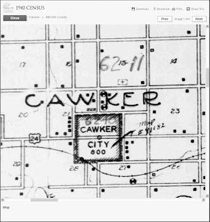
- The ED numbers are usually written in large but fainter numbers.
- In the example (right), Cawker township has ED 62-11, and Cawker City has ED 62-10.
- Jot down the EDs you want to view.
- Select
 to view another page and find other EDs for the county or city.
 - Select
 when you've reviewed all pages of the map.
 - If you want, repeat steps 1 through 5 for another map.
- Go to Descriptions view or Census Schedules view, below.

Descriptions view
Let's work from the Descriptions view.- Scroll though the groups of descriptions to a group you want to view.
- Select
 to see all the EDs for the group.
 - Jot down the ED you want to view.
- Repeat these steps for all EDs you're interested in.
- When you've found all EDs, select
 (above the descriptions).


No comments:
Post a Comment